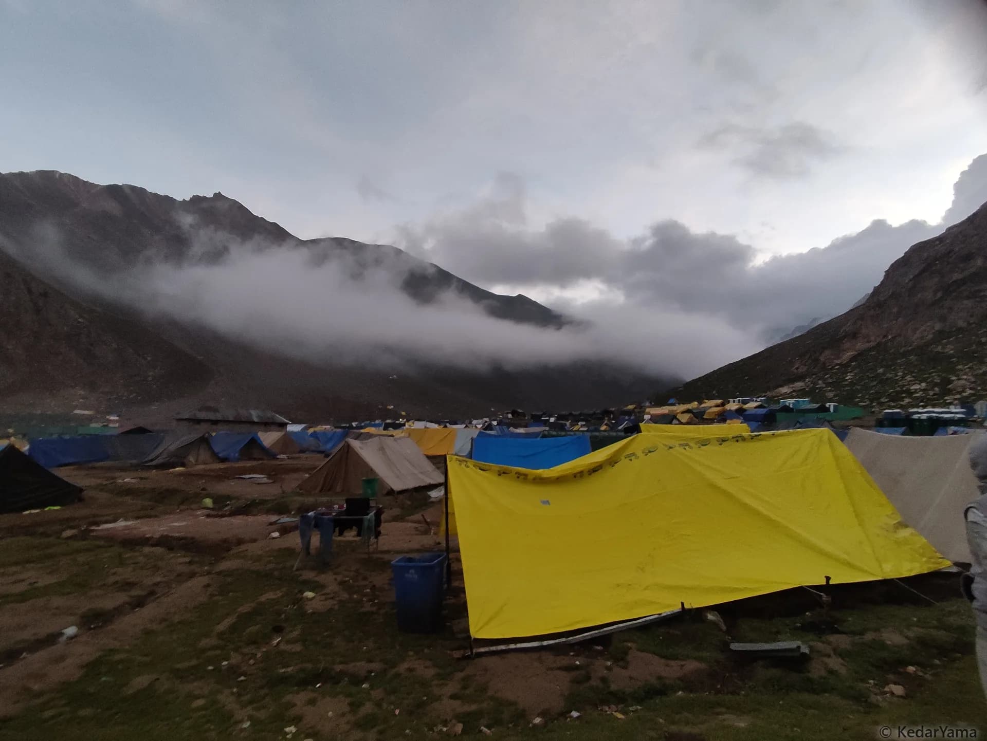
Amarnath Yatra

Kashmir Himalayas, Jammu & Kashmir

A high-altitude pilgrimage through Pahalgam or Baltal to the sacred ice shrine at 3,888 m in Kashmir.

Altitude

14029 ft

Duration

5 Days

Difficulty

Moderate to Hard

Best time

Jul – Aug

Standout Experiences

  • Walk beside the Lidder Valley from Pahalgam toward Chandanwari, then watch the landscape become dramatically barer around Sheshnag and Mahagunas Top.
  • Stand at Sheshnag, around 3,352 m, with the famous mountain lake and high ridges surrounding one of the most memorable camps on the traditional route.
  • Reach Panchtarni, where five streams meet beneath the high mountains, before making the final approach toward the Holy Cave.
  • Enter the 3,888 m Holy Cave for darshan of the naturally formed ice Shiva Lingam—the spiritual focus of the entire Amarnath Yatra. ([Kashmir Tourism Official][7])

Overview

Updated 27 Aug 2026

  • Amarnath is less a conventional Himalayan trek than a demanding high-altitude pilgrimage to a cave shrine at 3,888 m. The traditional Pahalgam approach takes you through Chandanwari, Pissu Top, Sheshnag and Panchtarni before the final walk to the Holy Cave. The route changes character as you climb: the green Lidder Valley gives way to stark high-altitude slopes, glacial streams and wide mountain views around Mahagunas and Panchtarni.
  • The Pahalgam route is the longer, more gradual approach, while the Baltal route is much shorter but steeper. From the official base camps, the Shrine Board lists roughly 32 km from the Pahalgam side and 14 km from Baltal to the Holy Cave. On the Pahalgam side, the memorable landmarks are Chandanwari, Pissu Top, Sheshnag, Mahagunas Top and Panchtarni; both approaches meet near Sangam before the final section to the cave.
  • The defining moment is reaching the Amarnath Cave, where devotees come for darshan of the naturally formed ice Shiva Lingam. At this altitude, weather can turn quickly, and the Shrine Board warns that temperatures may fall below 5°C even during the summer Yatra. That combination of faith, cold, altitude and a long mountain approach is what makes Amarnath feel very different from a normal Kashmir sightseeing trip.

Trek essentials

Max altitude

14,029 ft

Duration

5 Days

Total distance

72 km

Elevation gain

7,480 ft

Trek type

Out-and-back

Starting point

Chandanwari

Trail type

High-altitude pilgrimage trail with rocky paths, stone-paved sections, meadows and steep mountain passes

Average cost (indicative)

₹10000–₹18000 per person, excluding flights/train travel to Kashmir

Temp. range (°C)

0°C to 18°C

Snow months

May-June, with patches sometimes persisting into July

Rain risk

High during the July-August Yatra season; sudden rain, sleet and cloud can reduce visibility and make the trail slippery

Highest point

Mahagunas Pass — 4276 m

Holy Cave altitude

About 3888 m

Yatra permit

₹150 per permit in 2026

Medical certificate

Compulsory Health Certificate required for registration

RFID

Mandatory RFID card/tag for every registered Yatri
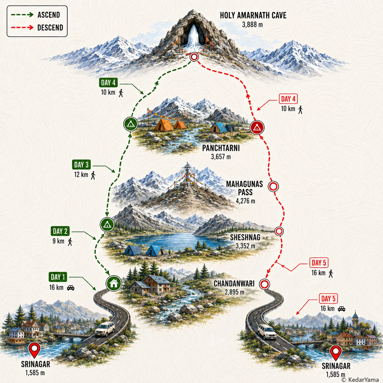
Trek Route

Graphical route map — high resolution terrain visualization

Detailed Itinerary

holiday_villageStayHomestay
signal_cellular_altDataPartial
boltPowerAvailable
  • Start after breakfast around 8 AM and drive from Srinagar toward Pahalgam, following the Lidder Valley through Anantnag and the green Kashmir countryside; allow roughly 3–4 hours depending on traffic and Yatra controls.
  • Reach Pahalgam around noon, have lunch and continue toward Chandanwari, the traditional roadhead about 16 km beyond Pahalgam; the road climbs beside the Lidder and narrows as the valley becomes more mountainous.
  • Spend the afternoon completing registration and security formalities, collecting your RFID tag if required at your designated point, and taking a short acclimatisation walk rather than trying to squeeze in a long trek.
  • The first impression of the trail is very different from the road below: rocky streambeds, pine-covered slopes and high mountain walls replace the broad Pahalgam valley, while ponies and fellow Yatris prepare for the early start.
  • Have an early dinner around 7 PM, keep rain gear and warm layers beside your sleeping bag, and aim to sleep by 9 PM so you are rested for the first full trekking day.

Images

Packing List

Must Have

Trekking Boots

layers

3-Layer Clothes

backpack

50L Backpack

water_drop

Hydration

timeline

Trekking Pole

ac_unit

Down Jacket

back_hand

Gloves

Woolen Socks

Woolen Socks

lightbulb

Headlamp

thermostat

Thermal Layers

medical_services

First Aid Kit

battery_charging_full

Power Bank

inventory_2

Raincoat

inventory_2

Waterproof Bags

inventory_2

Sun Cap

inventory_2

Sunscreen

inventory_2

Sunglasses

Good to Have

photo_camera

Action Cam

front_hand

Winter Gloves

directions_walk

Trek Gaiters

water_full

Hydration Bladder

checkroom

Quick-dry Towel

inventory_2

Walking Stick

inventory_2

Electrolytes

inventory_2

Personal Medications

Technical Overview

info

Mahagunas is higher than the cave

The Holy Cave sits at about 3888 m, but the Pahalgam route climbs higher before reaching it. From Sheshnag the trail rises steeply for about 4.6 km to Mahagunas Pass at 4276 m, the highest point on the route, before dropping to Panchtarni at 3657 m. That high-pass crossing is one of the day's biggest altitude challenges.

terrain

A long, varied mountain trail

The traditional Pahalgam approach changes character several times: the trail leaves the Chandanwari area, climbs through rocky terrain toward Pissu Top, opens out around Sheshnag Lake, then crosses an exposed high pass before descending into the broad Panchtarni meadows. The final approach from Panchtarni to the cave is comparatively gentler but remains exposed to rapidly changing high-altitude weather.

ac_unit

Cold, wet weather can arrive quickly

Even during the summer Yatra, temperatures at the upper camps can fall close to freezing, especially overnight or during bad weather. The Shrine Board specifically advises pilgrims to carry sufficient woollens, an umbrella or rain protection, windcheater and waterproof footwear because conditions can change abruptly. Keep clothing and food inside waterproof bags rather than relying on the weather staying dry.

info

The route is supported, but still remote

During the official Yatra, tented accommodation, langars, medical facilities, oxygen booths and emergency services are established along the route. Food and drinking water are commonly available through langars, while ponies, porters and palkis operate under government-notified rates. Outside the regulated Yatra period, this should not be treated as a normal independently accessible trekking route.

info

High Himalayan wildlife country

The trail passes through Kashmir's alpine landscape of meadows, streams and high mountain slopes, with coniferous forest around the lower approach and more open terrain above the tree line. Langurs and Himalayan birds can occasionally be seen around the lower and middle sections, while sightings of larger wildlife are uncommon. Keep food and waste secured and do not feed animals along the route.

When to Visit

calendar_today

Summer Pilgrimage

Jul – Aug

This is the only practical season for the organized Amarnath Yatra, with the Holy Cave accessible during the short summer pilgrimage window. Expect cold conditions at altitude, rapidly changing weather and large numbers of pilgrims, especially around Chandanwari, Sheshnag, Panchtarni and the Holy Cave.

ac_unit

Snowbound Season

Oct – Jun

The high route and Holy Cave are generally inaccessible during the long winter and spring period because of snow and severe mountain conditions. The cave remains snow-covered for most of the year and opens to pilgrims only for the short summer Yatra.

Other Information

Logistics & inclusions

  • check_circleSrinagar is the main air gateway. From Srinagar, pilgrims travel by road toward Pahalgam; Pahalgam is the traditional base for the Chandanwari route. The last motorable section reaches Chandanwari, from where the regulated foot journey begins.
  • check_circlePahalgam to Chandanwari is about 16 km by road. During the Yatra, access and movement are controlled, so pilgrims should follow the date and route printed on their Yatra permit.
  • check_circleTented accommodation is available at Chandanwari, Sheshnag and Panchtarni during the Yatra, while langars provide free food, drinking water and refreshments at numerous points.
  • check_circlePonies, porters and palkis are available along the Pahalgam route at government-notified rates. For example, the 2025 notified rate for Chandanwari to Holy Cave was ₹3500 after the initial 15-day period; 2026 rates should be checked against the latest Shrine Board notification before booking.
  • check_circleFor SANJY 2026, helicopter services are not available anywhere on the Yatra routes because the entire Yatra area has been declared a no-flying zone for the duration of the pilgrimage.
  • check_circleCarry only what you need on the trail. Cloakroom facilities are available at designated camps and the Holy Cave during the Yatra period.

Permits

Required: Yes

Registration and a Yatra Permit are mandatory for the official Amarnath Yatra. For 2026, advance registration through designated bank branches began on 15 April, requires Aadhaar-based biometric eKYC and a Compulsory Health Certificate issued by an authorised doctor on or after 8 April 2026. The permit fee is ₹150 per Yatra permit, and the permit is route-specific for either BALTAL or PAHALGAM. Every registered Yatri must also collect and wear the mandatory RFID card/tag before starting the Yatra.

Safety

Risks

  • High-altitude illness, headache, nausea, breathlessness and dehydration
  • Rapid weather changes, cold rain, sleet and poor visibility
  • Slippery rocks, steep sections and loose or uneven trail surfaces
  • Altitude exposure during the 4276 m Mahagunas Pass crossing
  • Crowds, pony traffic and congestion on narrow sections
  • Fatigue from long trekking days and the 72 km out-and-back journey
  • Stream crossings and locally waterlogged or muddy sections after rain

Precautions

  • Complete the mandatory Compulsory Health Certificate process and do not attempt the Yatra if you are unwell or inadequately acclimatised.
  • Walk slowly and steadily at altitude, drink regularly and take breaks before exhaustion sets in rather than after it.
  • Keep waterproof rain protection and warm layers immediately accessible; the Shrine Board warns that temperatures can abruptly fall below 5°C.
  • Wear proper trekking shoes with good grip and use trekking poles on steep, wet or uneven sections.
  • Stay on the designated Yatra trail, obey access-control timings and follow instructions from security, medical and Shrine Board personnel.
  • Carry your RFID tag throughout the Yatra and keep an emergency contact note with you.
  • If you develop severe breathlessness, confusion, persistent vomiting, inability to walk normally or rapidly worsening symptoms, stop ascending and seek medical assistance immediately.

Emergency

Official Yatra helplines for SANJY 2026 are 14464, 1800-180-7198 and 1800-180-7199. Medical and emergency facilities, including base hospitals, medical aid centres, oxygen booths and ambulatory services, are established at locations along the Yatra route during the official season.

Reviews

Frequently Asked Questions

Is the Amarnath Yatra difficult for beginners?expand_more
What is the best time to visit Amarnath?expand_more
How do I reach Amarnath from Delhi?expand_more
Is there snow at Amarnath in December?expand_more
How much does Amarnath Yatra registration cost?expand_more
What is the difference between the Amarnath Pahalgam route and Baltal route?expand_more
Do I need a medical certificate for the Amarnath Yatra?expand_more
Can I do the Amarnath Yatra without trekking the entire route?expand_more