RS
Rohit Sharma
August 2025
“The final climb tested every bit of my stamina, but seeing the Shrikhand Shivling at sunrise made every difficult step worthwhile. This is far more than a regular trek.”
Kullu Himalayas, Western Himalaya, Himachal Pradesh
“A demanding pilgrimage through alpine meadows and glaciers to the 5,227 m Shrikhand Mahadev Shivling.”
Altitude
17149 ft
Duration
6 Days
Difficulty
Expert
Best time
Jul – Aug
Updated 10 Aug 2026
Max altitude
17,149 ft
Duration
6 Days
Total distance
70 km
Elevation gain
12,959 ft
Trek type
Out and Back
Starting point
Jaon Village
Trail type
High-altitude pilgrimage trail
Average cost (indicative)
₹15000–22000 per person (guided package)
Temp. range (°C)
-5°C to 22°C
Snow months
June to early July, September (patches)
Rain risk
Very High during July–August monsoon
Best Season
Official yatra window in July (subject to annual notification)
Nearest Railhead
Shimla
Nearest Airport
Bhuntar (limited flights), Chandigarh for better connectivity
Mobile Network
Mostly available till Jaon; intermittent till Singhad; absent beyond
Trekking Boots
50L Backpack
3-Layer Clothes
Hydration
Trekking Pole
Down Jacket
Thermal Layers
Headlamp
Gloves
Winter Gloves

Woolen Socks
First Aid Kit
Power Bank
Action Cam
Quick-dry Towel
Trek Gaiters
Hydration Bladder
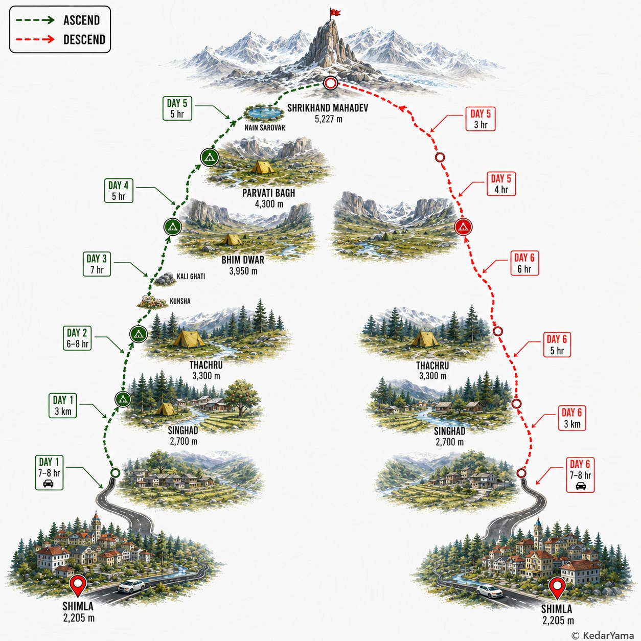
The trail begins on forest paths but quickly becomes relentlessly steep. After Thachru the terrain changes into rocky traverses, alpine meadows, moraine, loose boulders and snow patches depending on the season. The final approach beyond Nain Sarovar involves exposed ridges and glacier crossings where weather changes rapidly. Good balance and prior high-altitude trekking experience are strongly recommended.
The summit stands at over 5,200 metres where oxygen levels are significantly lower than at sea level. Most trekkers sleep above 3,500 metres for multiple nights before attempting the summit. Headache, fatigue and breathlessness are common if acclimatization is rushed. Hydration, slow pacing and immediate descent if AMS symptoms worsen are essential.
Unlike many Himalayan treks, the pilgrimage takes place during the monsoon season. Rain is frequent in the forests while higher camps can receive sleet, hail and fresh snow even in July. Mornings usually offer the safest summit window before clouds and thunderstorms build during the afternoon.
Lower sections pass through dense deodar, pine and oak forests before opening into alpine grasslands filled with seasonal wildflowers. Around Parvati Bagh, trekkers may spot Brahma Kamal and other Himalayan alpine blooms in good years. Himalayan monal, lammergeiers and mountain goats are occasionally seen in quieter stretches.
July – August
This is when the pilgrimage route is normally open and thousands of devotees and trekkers visit the shrine. Expect cold nights, regular rain, snow on higher sections and changing mountain weather.
September – June
Outside the official season the trail is generally covered by snow or becomes unsafe due to weather, landslides or unstable glaciers. Independent trekking is not recommended unless official authorities declare the route open.
Required: Yes
Registration, medical fitness certificate and local administration/yatra registration are generally mandatory during the official pilgrimage season. Requirements may change each year depending on weather and government notifications.
Seasonal rescue teams, police, medical camps and volunteers operate during the official yatra, but evacuation above Parvati Bagh is difficult and weather dependent. The fastest treatment for altitude illness is immediate descent.