RM
Rohan Mehta
May 2025
“I chose Sar Pass as my first Himalayan trek and couldn't believe how much the scenery changed every day. The snow crossing on summit day was the moment I'll remember for years.”
Parvati Valley, Kullu Himalayas, Himachal Pradesh
“Cross a snow-covered Himalayan pass from Kasol through forests, meadows, and high camps in Parvati Valley.”
Altitude
13799 ft
Duration
5 Days
Difficulty
Moderate
Best time
May – Jun Sep – Oct
Updated 10 Aug 2026
Max altitude
13,799 ft
Duration
5 Days
Total distance
33 km
Elevation gain
6,886 ft
Trek type
Point-to-point
Starting point
Kasol
Trail type
Forest, meadow, snow and mountain pass
Average cost (indicative)
₹8,500–₹12,500
Temp. range (°C)
-5°C to 20°C
Snow months
April to early June
Rain risk
Moderate during late May and June; high during monsoon
Base Camp
Kasol
Best Season
Late April to June
Nearest Airport
Bhuntar (Kullu)
Nearest Railway Station
Chandigarh
Mobile Network
Intermittent till Grahan; almost none after Min Thach
Trekking Boots
3-Layer Clothes
50L Backpack
Hydration
Trekking Pole
Down Jacket
Thermal Layers
Gloves

Woolen Socks
Headlamp
First Aid Kit
Power Bank
Action Cam
Quick-dry Towel
Winter Gloves
Trek Gaiters
Hydration Bladder
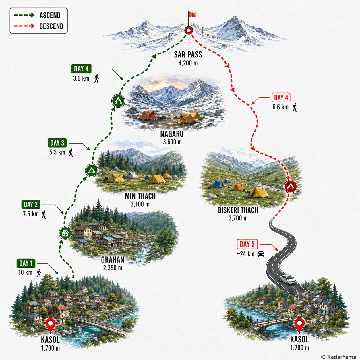
The Sar Pass Trek begins on well-defined village paths before entering dense pine, oak and rhododendron forests. As the trek gains altitude, the forests give way to wide alpine meadows and eventually snow-covered slopes leading to the pass. The descent after the pass is steep over snowfields before rejoining grassy ridges and forest trails. Expect a combination of dirt tracks, rocky sections, snow patches and occasional stream crossings.
The trek climbs from around 1,700 metres at Kasol to nearly 4,200 metres at Sar Pass in just a few days. While the ascent is gradual through Grahan and Nagaru, the final climb to the pass reaches high altitude quickly. Staying hydrated, walking at a steady pace and avoiding overexertion help reduce the chances of Acute Mountain Sickness. Trek leaders monitor trekkers closely during the higher camps.
Daytime temperatures usually range between 10°C and 20°C in the lower camps, while higher camps remain much colder. Nights at Nagaru often fall below freezing, especially in May. Snow remains on the upper trail well into early summer, while afternoon clouds and occasional rain showers are common. Carry waterproof layers even during clear weather.
The lower trail passes through thick Himalayan forests filled with pine, cedar, oak and rhododendron. During spring the rhododendron blooms paint the hillsides red and pink. Himalayan birds including monals, woodpeckers and various pheasants are commonly spotted, while langurs and other small mammals are occasionally seen along quieter stretches.
May – June
This is the most popular time for the Sar Pass Trek. Expect blooming forests, snowy slopes near the pass, cool temperatures, and lively trekking groups.
September – October
After the monsoon, the skies are usually clear and the forests look fresh. Snow is limited, but the visibility, golden meadows, and quieter trails make this an excellent alternative season.
Required: Yes
Forest entry permissions are required and are generally arranged by registered trek operators. Carry a government-issued photo ID and passport-size photographs. Foreign nationals should carry passport and visa copies.
The nearest major medical facilities are in Kasol and Bhuntar. Mobile connectivity becomes unreliable after Grahan. Trek leaders carry first-aid kits, oxygen cylinders and evacuation protocols for emergencies.