Sach Pass Trek

Pir Panjal Range, Himachal Pradesh

Cross a wild 4,420 m Himalayan pass linking Chamba and Pangi through snowfields, glaciers, and remote mountain valleys.

Altitude

14518 ft

Duration

8 Days

Difficulty

Moderate to Hard

Best time

Jun – Jul Aug – Sep

Standout Experiences

  • Cross one of Himachal Pradesh's highest and most adventurous mountain passes at around 4,420 metres.
  • Walk from lush Chamba forests into the stark, remote landscapes of the Pangi Valley on a single journey.
  • Experience a Himalayan trail that still feels wild, quiet, and far less crowded than famous trekking routes.
  • Watch snowfields, glaciers, waterfalls, and alpine meadows unfold within just a few days of trekking.

Overview

Updated 10 Aug 2026

  • Sach Pass Trek is one of Himachal Pradesh's toughest high-altitude crossings, taking you from the green valleys of Chamba into the remote Pangi Valley over Sach Pass at around 4,420 metres. Unlike popular trekking routes, this trail still feels raw and isolated. Shepherd paths, lingering snowfields, glacier-fed streams, and dramatic mountain scenery make every day feel like a genuine Himalayan expedition rather than a crowded trekking circuit.
  • The trail constantly changes as you gain height. Forests of pine and deodar gradually give way to alpine meadows, rocky slopes, and long stretches of snow that often survive well into early summer. From the top of Sach Pass, the views stretch across the Pir Panjal Range, with hanging glaciers, deep valleys, and distant peaks in every direction. The weather can change within minutes, adding to both the challenge and the excitement.
  • Reaching the pass is only part of the experience. The villages on the Chamba and Pangi sides offer a glimpse into one of Himachal's most isolated regions, where traditional wooden homes, ancient temples, and Gaddi shepherd culture remain a part of everyday life. This combination of demanding terrain and authentic mountain life makes Sach Pass stand apart from more commercial Himalayan treks.

Trek essentials

Max altitude

14,518 ft

Duration

8 Days

Total distance

39 km

Elevation gain

6,398 ft

Trek type

Point-to-point

Starting point

Traila

Trail type

Forest trail, alpine meadows, mountain pass

Average cost (indicative)

₹18,000–28,000 per person (ex-Dharamshala/Chamba, guided expedition)

Temp. range (°C)

-5°C to 20°C

Snow months

June to early July, October

Rain risk

High during July–August due to monsoon

Best Season

Late June to September

Nearest Major Town

Chamba

Exit Point

Raoli / Killar Road
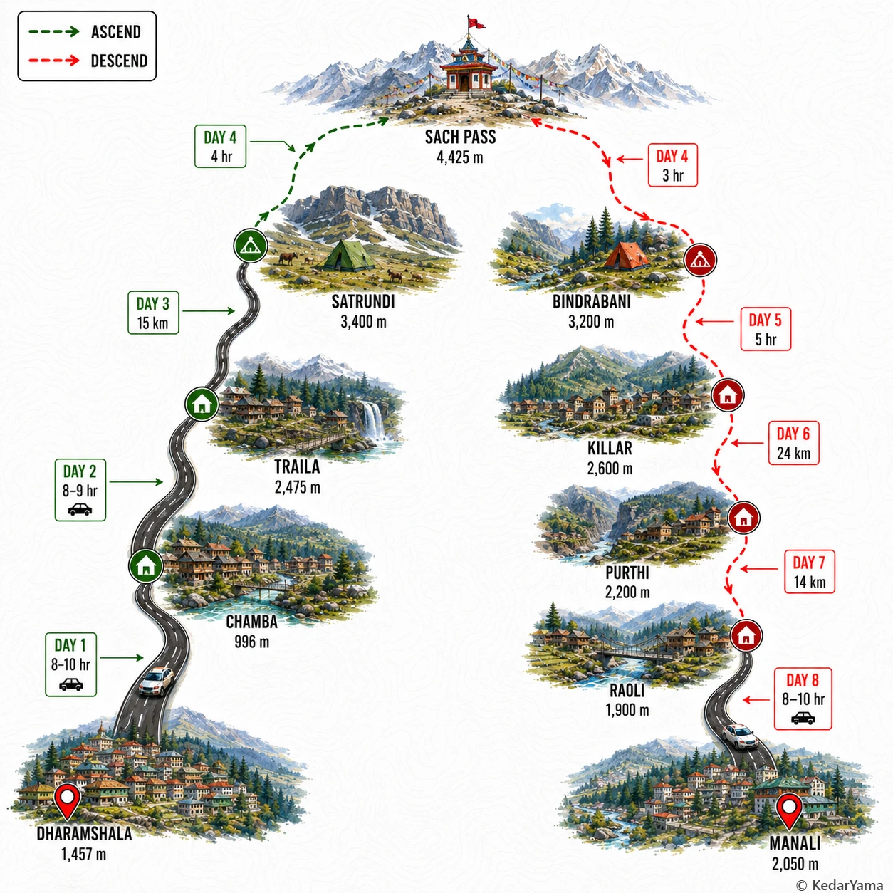
Trek Route

Graphical route map — high resolution terrain visualization

Detailed Itinerary

holiday_villageStayHomestay
signal_cellular_4_barDataFull
boltPowerAvailable
  • Meet the team early in the morning and begin the 8–10 hour drive towards Chamba, following winding Himalayan roads through Kangra valleys and cedar-covered hills.
  • The road passes tea gardens, mountain villages and viewpoints overlooking the Ravi River before reaching the historic town of Chamba by evening.
  • Check into the guesthouse around 6–7 PM, complete a trek briefing, sort personal gear and rest well before entering the remote Pangi region.

Packing List

Must Have

Trekking Boots

layers

3-Layer Clothes

backpack

50L Backpack

water_drop

Hydration

timeline

Trekking Pole

ac_unit

Down Jacket

back_hand

Gloves

Woolen Socks

Woolen Socks

lightbulb

Headlamp

thermostat

Thermal Layers

medical_services

First Aid Kit

inventory_2

Rain Cover

battery_charging_full

Power Bank

Good to Have

photo_camera

Action Cam

checkroom

Quick-dry Towel

water_full

Hydration Bladder

directions_walk

Trek Gaiters

front_hand

Winter Gloves

inventory_2

Sunscreen

inventory_2

Sunglasses

Technical Overview

terrain

A True Himalayan Pass Crossing

The trail begins through mixed deodar and pine forests before entering wide alpine meadows around Satrundi. Above 3,500 metres the vegetation disappears, giving way to loose scree, glacial snow patches and rocky mountain slopes. The crossing over Sach Pass is exposed to strong winds and rapidly changing weather before descending into the greener Pangi Valley.

info

High Altitude Demands Respect

Although the trekking distance is not exceptionally long, the pass rises above 4,400 metres where oxygen levels are significantly lower. Most trekkers feel the effects of altitude during the climb from Satrundi. Proper acclimatization, slow walking pace, hydration and avoiding alcohol greatly reduce the risk of Acute Mountain Sickness.

ac_unit

Weather Changes Very Quickly

Morning skies are usually clear but clouds frequently build after noon during the monsoon season. Rain at lower elevations can become snowfall or sleet near the pass even in summer. Carry waterproof layers every day because conditions can change within minutes.

info

Forests, Meadows and Wildlife

The lower trail passes through dense deodar forests, Himalayan pine and birch before opening into flower-filled alpine meadows during July and August. Himalayan monal, lammergeier, marmots and grazing sheep are commonly seen. Higher sections remain barren with patches of old snow surviving well into summer.

When to Visit

calendar_today

Early Summer Snow

June – July

Snow still covers sections near the pass, making the crossing more adventurous. Expect cold nights, changing weather, and spectacular white mountain scenery.

calendar_today

Late Summer and Post-Monsoon

August – September

The valleys turn green, wildflowers bloom, and the weather is usually more stable. This is the most comfortable period for completing the trek while still enjoying excellent mountain views.

Other Information

Logistics & inclusions

  • check_circleExpedition generally starts with vehicle transfer from Dharamshala or Chamba to Traila.
  • check_circleRoad approach follows Chamba–Tissa–Bairagarh before reaching the trek start.
  • check_circleLimited mobile connectivity after Bairagarh; BSNL works intermittently in a few villages.
  • check_circleExtra luggage can usually be left at the operator's guesthouse in Chamba.
  • check_circleSupport staff normally use mules or porters for camping equipment.
  • check_circleRoad across Sach Pass remains open only from late June until October depending on snow clearance.

Permits

Required: Yes

No special trekking permit is normally required for Indian citizens, but all participants must register with the trekking operator. Forest permissions and camping approvals are generally arranged by the organizer. Foreign nationals should carry passport and visa copies for identification.

Safety

Risks

  • Acute Mountain Sickness above 3500 m
  • Rapid weather changes with snow or hail
  • Loose scree and slippery rocks near the pass
  • Landslides and road closures during monsoon
  • Cold winds causing hypothermia

Precautions

  • Acclimatize properly before the pass day.
  • Start early every morning to avoid afternoon weather.
  • Carry waterproof clothing and sufficient warm layers.
  • Drink 3-4 litres of water daily.
  • Follow trek leader instructions during stream crossings and snow sections.

Emergency

Nearest medical facilities are at Chamba before the trek and Killar after crossing the pass. Evacuation is weather dependent and may involve mule support followed by vehicle transport.

Reviews

Frequently Asked Questions

What is the best time to do the Sach Pass Trek?expand_more
Is the Sach Pass Trek suitable for beginners?expand_more
How difficult is the Sach Pass Trek?expand_more
How do I reach the starting point of the Sach Pass Trek from Delhi?expand_more
Do I need permits for the Sach Pass Trek?expand_more
Will I find snow on the Sach Pass Trek?expand_more
Sach Pass Trek or Hampta Pass Trek: which is better?expand_more