Phulara Ridge Trek

Govind Pashu Vihar, Garhwal Himalaya, Uttarakhand

Walk for hours on a narrow Himalayan ridge with uninterrupted mountain views and quiet alpine meadows.

Altitude

12345 ft

Duration

6 Days

Difficulty

Moderate

Best time

May – Jun Sep – Nov

Standout Experiences

  • Spend nearly four hours walking on a continuous Himalayan ridgeline instead of simply climbing to a viewpoint.
  • Enjoy wide views of Swargarohini, Bandarpoonch and Kala Nag almost the entire time you're on the ridge.
  • Camp in quiet alpine meadows where you'll often hear birds more than other trekking groups.
  • Experience an offbeat Garhwal trek that feels wild and peaceful even during the trekking season.

Overview

Updated 11 Aug 2026

  • The Phulara Ridge Trek is one of the rare Himalayan treks where the ridge itself is the main attraction. Instead of climbing to a summit and heading back, you spend nearly four hours walking along a high grassy ridgeline with wide-open views on both sides. From the ridge, you can see Swargarohini, Bandarpoonch, Kala Nag and the surrounding Garhwal peaks stretching across the horizon. It is a feeling that very few treks in India can match.
  • The journey begins from the quiet villages of the Tons Valley and climbs through dense pine, oak and deodar forests before opening into meadows filled with wildflowers in late spring. Camps at Akondi, Bhoj Gadi and Pushtara are peaceful and far less crowded than many famous Himalayan routes. The changing landscape keeps every day interesting without feeling rushed.
  • Although the trek reaches around 3,760 m (12,345 ft), the itinerary is gradual enough for fit beginners who prepare well. Summer brings fresh green meadows, lingering snow patches and blooming flowers, while autumn offers crystal-clear skies, golden grasslands and excellent mountain photography. If you want an offbeat trek with unforgettable ridge walking rather than crowded campsites, Phulara Ridge is one of the best choices in Uttarakhand.

Trek essentials

Max altitude

12,345 ft

Duration

6 Days

Total distance

26 km

Elevation gain

5,945 ft

Trek type

Point-to-point

Starting point

Kotgaon

Trail type

Forest trails, alpine meadows and exposed ridge

Average cost (indicative)

₹13,500–₹17,500 excluding travel to Dehradun

Temp. range (°C)

-2°C to 18°C depending on season

Snow months

January to April (patches may remain into early May)

Rain risk

High during July–August monsoon; avoid peak monsoon

Best Season

May–June and September–November

Nearest Railway Station

Dehradun

Nearest Airport

Jolly Grant Airport, Dehradun

Network

Intermittent at Kotgaon; unavailable on most of the trek
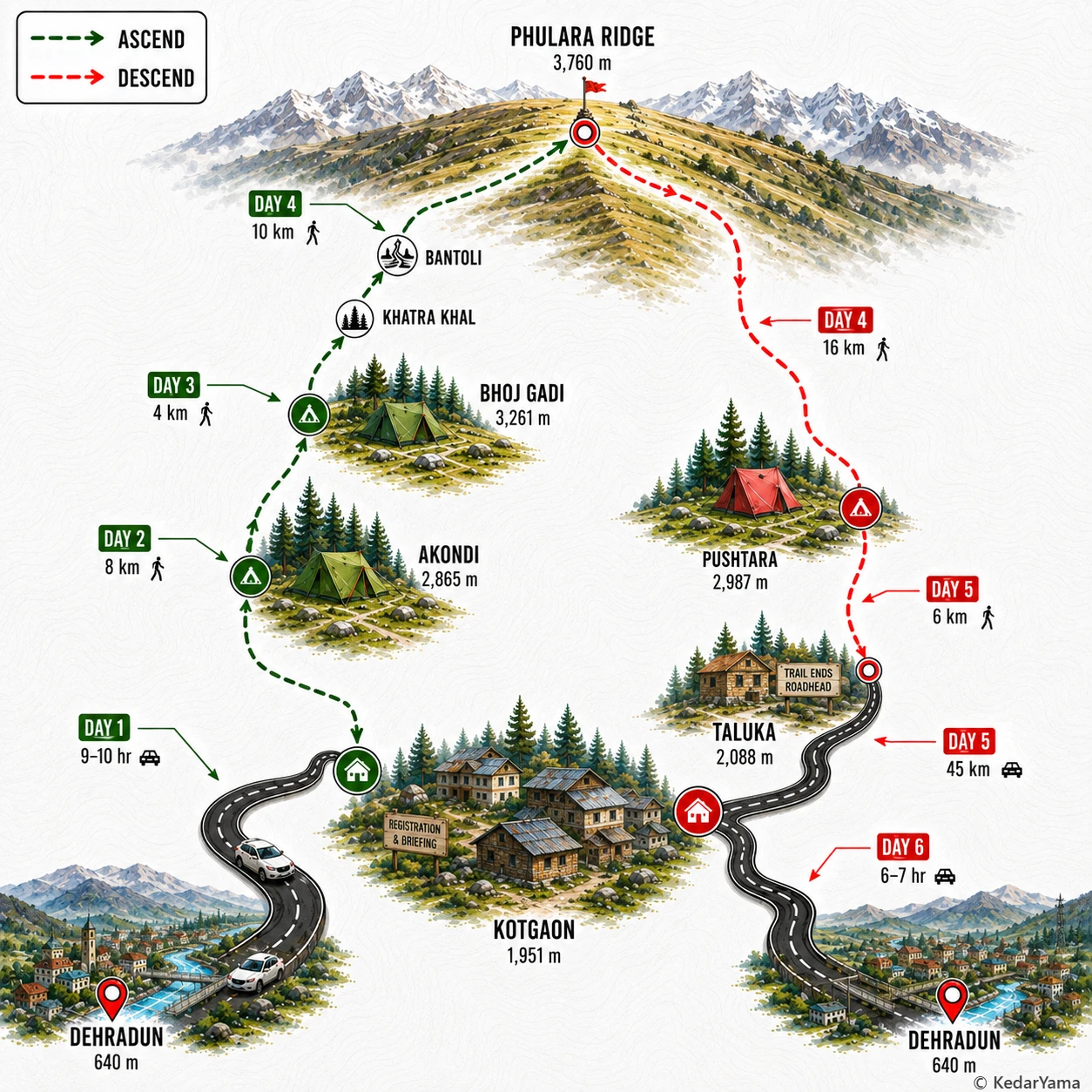
Trek Route

Graphical route map — high resolution terrain visualization

Detailed Itinerary

holiday_villageStayHomestay
signal_cellular_altDataPartial
boltPowerAvailable
  • Meet the team around 6:30 AM and begin the 9–10 hour mountain drive towards Kotgaon, following the Yamuna valley before climbing through Mussoorie and the interior roads of Uttarkashi.
  • The journey passes Naugaon, Purola, Mori and the beautiful Tons valley with meal breaks at roadside dhabas and plenty of changing Himalayan scenery.
  • Reach Kotgaon by early evening, settle into the homestay, complete registration, check your gear and enjoy sunset views of the Swargarohini range before an early dinner.

Packing List

Must Have

Trekking Boots

layers

3-Layer Clothes

backpack

50L Backpack

water_drop

Hydration

timeline

Trekking Pole

ac_unit

Down Jacket

thermostat

Thermal Layers

lightbulb

Headlamp

medical_services

First Aid Kit

back_hand

Gloves

Woolen Socks

Woolen Socks

Good to Have

battery_charging_full

Power Bank

checkroom

Quick-dry Towel

photo_camera

Action Cam

water_full

Hydration Bladder

front_hand

Winter Gloves

directions_walk

Trek Gaiters

Technical Overview

terrain

A Ridge Walk Unlike Any Other

The trail begins inside dense deodar, pine, oak and rhododendron forests before emerging into rolling alpine meadows. The signature section is the continuous Phulara Ridge where you walk for several kilometres with open views on both sides instead of simply crossing a pass. The ridge is broad in most places but exposed to wind, while the descent towards Pushtara returns to grassy slopes and forests.

info

Altitude and Acclimatisation

Although the maximum altitude is only around 12,345 ft, the first trekking day gains nearly 3,000 ft from Kotgaon, making it physically demanding. The following days gain altitude more gradually, helping the body acclimatise. Staying hydrated, maintaining a steady pace and reporting headache or nausea early greatly reduce the risk of altitude sickness.

ac_unit

Weather Through the Season

Spring brings blooming rhododendrons, pleasant daytime temperatures and lingering snow patches near the ridge. Autumn offers crystal-clear mountain views with cool mornings and cold nights. Winds are common on the exposed ridge, while afternoon weather can change quickly with clouds or brief showers.

info

Forests, Meadows and Wildlife

The trek passes through rich Himalayan forests filled with deodar, pine, oak and birch before reaching expansive bugyals. Himalayan monals are frequently spotted around the ridge, while langurs, musk deer and numerous mountain birds inhabit the forest. Wildflowers cover the meadows during late spring and early summer.

When to Visit

calendar_today

Green meadows and wildflowers

May – June

Snow begins melting, alpine flowers bloom and the meadows turn bright green. Days are pleasant for trekking, while nights remain cold at higher camps.

calendar_today

Clear skies and golden landscapes

Mid-September – November

After the monsoon, mountain views become exceptionally clear and the grasslands turn golden. Cool temperatures and dry weather make this the favourite season for photography.

Other Information

Logistics & inclusions

  • check_circleReach Dehradun a day before departure.
  • check_circleShared vehicles typically drive 9–10 hours from Dehradun to Kotgaon.
  • check_circleReturn is via Taluka to Kotgaon by road before driving back to Dehradun.
  • check_circleExtra luggage can usually be left safely at the base camp.
  • check_circleMules or porters are available for backpack offloading at additional cost.
  • check_circleCarry government-issued photo ID for registration and forest entry.

Permits

Required: Yes

Forest entry permissions are mandatory and are generally arranged by registered trek operators. Independent trekkers should obtain permissions through the local forest authorities before starting the trek.

Safety

Risks

  • Rapid altitude gain on the first trekking day.
  • Strong winds and exposure along the ridge.
  • Slippery rocks or snow patches during early season.
  • Sudden mountain weather changes.
  • Remote trail with limited communication.

Precautions

  • Acclimatise properly and stay hydrated.
  • Start trekking early every morning.
  • Carry warm layers even during sunny days.
  • Wear trekking shoes with good grip and use trekking poles.
  • Follow the trek leader on exposed ridge sections and avoid wandering off the trail.

Emergency

The nearest road heads are Kotgaon and Taluka. Mobile connectivity is unreliable beyond the base village. Certified trek operators carry first-aid kits, oxygen cylinders and evacuation equipment.

Reviews

Frequently Asked Questions

Is Phulara Ridge Trek good for beginners?expand_more
What is the best time to do the Phulara Ridge Trek?expand_more
How do I reach the Phulara Ridge Trek from Delhi?expand_more
Does the Phulara Ridge Trek have snow?expand_more
Do I need a permit for the Phulara Ridge Trek?expand_more
How difficult is the ridge walk itself?expand_more
Which is better: Phulara Ridge Trek or Kedarkantha Trek?expand_more
How many days does the Phulara Ridge Trek take?expand_more