Dronagiri Village Trek

Garhwal Himalaya, Uttarakhand

Walk to the legendary Himalayan village beneath Dunagiri Peak, where mythology, ancient temples and alpine meadows meet.

Altitude

15092 ft

Duration

8 Days

Difficulty

Moderate to Hard

Best time

Apr – Jun Sep – Nov

Standout Experiences

  • Walk through the legendary village linked to the Sanjeevani story from the Ramayana.
  • Spend time at the ancient Dunagiri Temple with panoramic views across the Garhwal Himalaya.
  • Enjoy peaceful forest trails without the crowds found on Uttarakhand's more famous treks.
  • Experience authentic mountain village life while staying close to one of the great peaks of the Nanda Devi region.

Overview

Updated 10 Aug 2026

  • Dronagiri is one of those Himalayan places where every trail has a story. The village sits high in Chamoli district beneath the massive Dunagiri Peak, surrounded by oak and rhododendron forests, terraced fields and old stone houses. As you walk through the village, you'll hear local stories connected to the Ramayana, visit the centuries-old Dunagiri Temple, and watch snow-covered summits rise above the valley. It feels less like a commercial trek and more like stepping into a living mountain culture.
  • The trail is ideal if you enjoy quiet mountain walks instead of crowded trekking routes. Spring brings blooming rhododendrons, while autumn offers crisp skies with clear views of Dunagiri, Hathi-Ghoda and nearby Himalayan ranges. The pace is relaxed, giving you time to interact with villagers, photograph traditional architecture and enjoy peaceful forest sections. For travelers looking to combine mythology, history and Himalayan scenery in one journey, Dronagiri offers a refreshing alternative to busier treks.

Trek essentials

Max altitude

15,092 ft

Duration

8 Days

Total distance

46 km

Elevation gain

7,382 ft

Trek type

Out and Back

Starting point

Jumma Village

Trail type

Village trail, forest, alpine valley and glacier approach

Average cost (indicative)

₹18,000–₹28,000 per person

Temp. range (°C)

-5°C to 18°C

Snow months

December–April

Rain risk

High during July–August monsoon

Nearest Town

Joshimath

Nearest Airport

Jolly Grant Airport, Dehradun

Nearest Railway Station

Haridwar / Rishikesh

Best Season

May–June and September–October
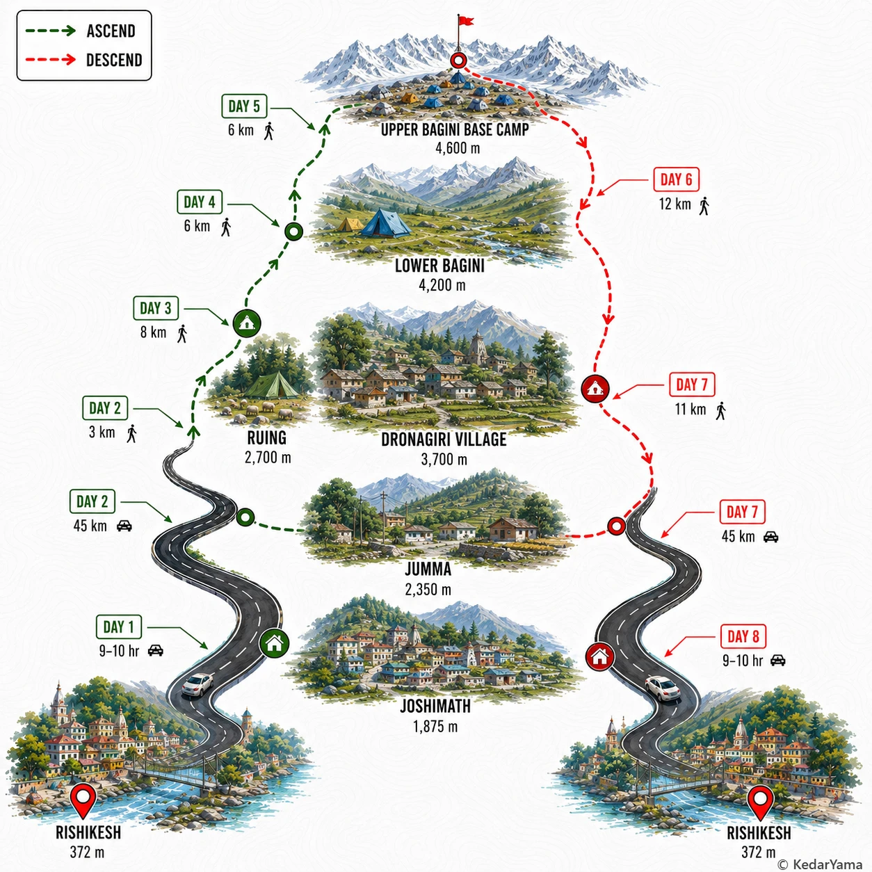
Trek Route

Graphical route map — high resolution terrain visualization

Detailed Itinerary

holiday_villageStayHomestay
signal_cellular_4_barDataFull
boltPowerAvailable
  • Leave Rishikesh around 6 AM for a full-day mountain drive following the Ganga and Alaknanda valleys through Devprayag, Rudraprayag, Karnaprayag and Chamoli.
  • Stop for breakfast and lunch at highway towns while the road gradually climbs into the Garhwal Himalaya with changing views of deep river gorges and pine-covered slopes.
  • Reach Joshimath by evening after 9–10 hours, complete the trek briefing, check equipment and rest well before the higher-altitude days begin.

Packing List

Must Have

Trekking Boots

backpack

50L Backpack

layers

3-Layer Clothes

ac_unit

Down Jacket

thermostat

Thermal Layers

water_drop

Hydration

timeline

Trekking Pole

lightbulb

Headlamp

medical_services

First Aid Kit

back_hand

Gloves

Woolen Socks

Woolen Socks

Good to Have

battery_charging_full

Power Bank

photo_camera

Action Cam

checkroom

Quick-dry Towel

front_hand

Winter Gloves

directions_walk

Trek Gaiters

water_full

Hydration Bladder

Technical Overview

terrain

Trail & Terrain

The trail begins from the roadhead near Jumma and climbs through traditional Himalayan villages before entering forests of oak, birch and rhododendron. Higher up the landscape opens into alpine meadows, boulder fields and glacial valleys leading towards Bagini Base Camp. Expect rocky sections, loose moraine and occasional stream crossings, especially after snowmelt.

info

Altitude & Acclimatisation

The route gains well over 2,000 metres in elevation over several days, making proper acclimatisation essential. Most trekkers spend a night around Dronagiri Village before continuing higher. Walking slowly, staying hydrated and recognising early AMS symptoms greatly improve safety.

ac_unit

Weather

Summer days are pleasant while mornings and nights remain cold above 3,500 metres. Post-monsoon brings the clearest mountain views and stable weather. Afternoon clouds and occasional rain or snowfall are always possible at higher camps, so layered clothing and waterproof gear are necessary.

info

Nature Along the Trail

Lower elevations feature walnut trees, wild plum, oak and rhododendron forests around Dronagiri Village. Above the tree line, alpine grasslands and glacial vegetation dominate. Himalayan monal, bharal, foxes and soaring Himalayan griffons are occasionally spotted in the upper valley.

When to Visit

local_florist

Blooming Forest Trails

April – June

Pleasant temperatures, flowering rhododendrons and comfortable trekking conditions make this the most popular season. The surrounding peaks remain snow-covered while the lower forests turn green.

calendar_today

Lush But Wet

July – August

The mountains become incredibly green, but frequent rain can make trails slippery and increase the risk of landslides on approach roads. Flexible travel plans are recommended.

calendar_today

Clear Himalayan Views

September – November

Fresh post-monsoon air brings excellent visibility and cool weather. This is one of the best seasons for photography and long mountain views.

ac_unit

Snowy Mountain Escape

December – February

Snow transforms the village into a winter landscape, but temperatures drop well below freezing and road conditions can become unpredictable. Warm clothing is essential.

Other Information

Logistics & inclusions

  • check_circleReach Joshimath from Rishikesh or Haridwar by road, then drive about 45 km to Jumma roadhead.
  • check_circleMost trekking groups arrange transport from Rishikesh to Joshimath and onward to the trailhead.
  • check_circleOnly light backpacks should be carried during the trek; porters or mules are commonly available for expedition loads.
  • check_circleMobile connectivity becomes unreliable after Jumma and is generally unavailable at higher camps.
  • check_circleAccommodation is a mix of GMVN stay, village lodge/homestay and tents depending on the campsite.

Permits

Required: Yes

Forest permission and local entry registration are required for trekking beyond Dronagiri Village. Organised trekking operators usually arrange permits. Carry a valid government-issued photo ID.

Safety

Risks

  • Altitude sickness above 3500 m
  • Rockfall and loose moraine near the glacier
  • Rapid weather changes
  • Cold exposure and snow in early season
  • Remote terrain with limited communication

Precautions

  • Maintain a slow pace and hydrate regularly.
  • Spend an acclimatisation night before moving to higher camps.
  • Carry proper layered clothing and waterproof protection.
  • Follow certified local guides and avoid leaving the marked trail.
  • Begin trekking early each morning to avoid afternoon weather.

Emergency

The nearest major medical facilities are in Joshimath. Mobile network is limited after Jumma, so trekking with an experienced guide carrying first-aid and emergency communication equipment is strongly recommended.

Reviews

Frequently Asked Questions

Is the Dronagiri Village Trek suitable for beginners?expand_more
What is the best time to visit Dronagiri?expand_more
How do I reach Dronagiri from Delhi?expand_more
Does Dronagiri receive snowfall?expand_more
Do I need permits for the Dronagiri Village Trek?expand_more
Is Dronagiri better than Kuari Pass?expand_more
Can I visit Dronagiri as a weekend trip?expand_more