Chakrata Trek

Garhwal Himalaya, Uttarakhand

Walk through deodar forests, hidden caves and high Himalayan viewpoints in Uttarakhand's quiet cantonment hills.

Altitude

9022 ft

Duration

3 Days

Difficulty

Easy to Moderate

Best time

Apr – Jun Sep – Nov

Standout Experiences

  • Walk beneath towering deodar forests at Deoban with uninterrupted Himalayan views that stay surprisingly crowd-free.
  • Explore the natural limestone passages of Budher Caves after an adventurous forest approach trek.
  • Combine waterfalls, caves, forests and ridge walks in a single weekend without changing base camps.
  • Experience one of Uttarakhand's quietest trekking destinations where the cantonment setting has preserved its natural character.

Overview

Updated 11 Aug 2026

  • Chakrata is one of those rare Himalayan hill stations where the trails still feel quieter than the cafés. Instead of following a single marked trekking route, you'll spend your days walking through dense deodar forests around Deoban, descending to Tiger Falls, exploring the limestone Budher Caves, and climbing open ridges that look across the snow-covered peaks of Bandarpoonch, Swargarohini and the western Himalaya. The pace is relaxed, making it ideal for anyone who wants real mountain walks without committing to a high-altitude expedition.
  • The forests around Deoban are the heart of the Chakrata trekking experience. Tall deodar trees block out the sun for long stretches before suddenly opening to sweeping Himalayan panoramas. Depending on the season, you'll walk through rhododendron blooms in spring, misty green forests during the monsoon, crisp golden mornings in autumn, or occasional snow-covered trails in winter. Birdwatchers often consider Deoban one of the finest forest walks in western Uttarakhand.
  • Unlike many popular Himalayan destinations, Chakrata has remained protected by its cantonment status, keeping commercial development limited. That means quieter viewpoints, cleaner trails and a slower rhythm. Add the adventurous walk into Budher Caves, the refreshing hike to Tiger Falls and easy ridge walks around Chilmiri and Mundali, and you have a destination that works equally well for first-time trekkers, photographers and experienced hikers looking for a peaceful weekend in the mountains.

Trek essentials

Max altitude

9,022 ft

Duration

3 Days

Total distance

10 km

Elevation gain

2,133 ft

Trek type

Out and Back

Starting point

Gorcha Village

Trail type

Forest trail, ridge walk, meadow and cave section

Average cost (indicative)

₹4,500–7,000 per person

Temp. range (°C)

5°C to 24°C (season dependent)

Snow months

December–February

Rain risk

High during July–September

Nearest Railhead

Dehradun Railway Station

Nearest Airport

Jolly Grant Airport, Dehradun

Best Season

March–June and September–November

Network

Limited after Chakrata; usually unavailable on trek
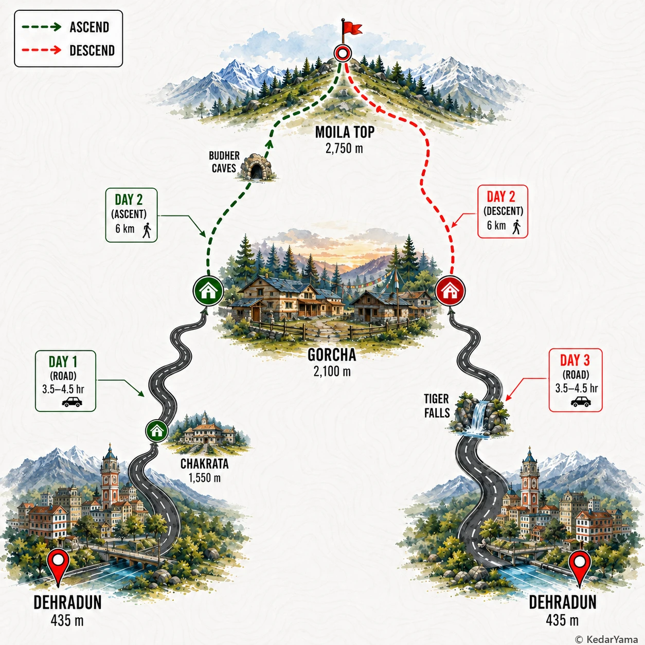
Trek Route

Graphical route map — high resolution terrain visualization

Detailed Itinerary

holiday_villageStayHomestay
signal_cellular_altDataPartial
boltPowerAvailable
  • Leave Dehradun around 7:00 AM and spend about 4 hours driving through Vikasnagar and the Yamuna valley before climbing into the pine-covered hills of Chakrata.
  • After breakfast on the way, continue towards Gorcha Village where the trek begins, reaching by early afternoon with plenty of time to settle into your homestay.
  • Spend the evening checking gear, taking a short walk around the surrounding deodar forest and enjoying sunset views over the lower Himalayan ridges before an early dinner and overnight stay.

Packing List

Must Have

Trekking Boots

layers

3-Layer Clothes

backpack

50L Backpack

water_drop

Hydration

timeline

Trekking Pole

lightbulb

Headlamp

medical_services

First Aid Kit

battery_charging_full

Power Bank

Good to Have

ac_unit

Down Jacket

thermostat

Thermal Layers

back_hand

Gloves

Woolen Socks

Woolen Socks

photo_camera

Action Cam

checkroom

Quick-dry Towel

front_hand

Winter Gloves

Technical Overview

terrain

Forest Trails and Limestone Caves

The trek begins through dense deodar, pine and oak forests before climbing gradually onto open ridges around Moila Top. The trail is mostly dirt with scattered rocks and a few steeper sections near the ridge. A short detour leads into the Budher limestone caves where the ground becomes uneven, damp and slippery, making a headlamp essential.

ac_unit

Weather Throughout the Year

Spring and early summer offer pleasant daytime temperatures with cool mornings and excellent visibility. Monsoon months bring slippery trails, leeches in forest patches and frequent fog that can reduce visibility. Winter often brings snowfall around Moila Top and nearby ridges, turning the trail into an easy snow trek with significantly colder nights.

info

Forest Ecosystem

The trail passes through extensive deodar, pine, oak and rhododendron forests. In spring, rhododendron blooms add bright red patches to the landscape while birds such as Himalayan monal, woodpeckers and laughing thrushes are commonly spotted. Langurs, barking deer and other shy Himalayan wildlife may occasionally be seen early in the morning.

info

Altitude and Fitness

Although the maximum altitude remains below 3000 metres, the trek involves continuous walking on undulating ridges with moderate climbs. Most trekkers do not experience altitude sickness, but steady pacing, hydration and regular breaks make the experience more enjoyable. Basic cardiovascular fitness is sufficient for first-time trekkers.

When to Visit

local_florist

Forest trails and blooming rhododendrons

April – June

Pleasant temperatures make this the most comfortable trekking season. Deodar forests stay green, rhododendrons bloom across higher slopes and Himalayan views are usually excellent.

calendar_today

Lush landscapes and misty forests

July – August

The forests become intensely green and waterfalls flow at full strength. Expect slippery trails, regular rain and limited mountain views on many days.

calendar_today

Crystal-clear Himalayan panoramas

September – November

Fresh air after the monsoon creates some of the clearest mountain views of the year. Comfortable daytime temperatures make this another excellent trekking season.

ac_unit

Snow on the higher ridges

December – February

Cold weather brings occasional snowfall around the higher viewpoints and nearby Mundali. Carry warm clothing and expect icy conditions on shaded trails.

Other Information

Logistics & inclusions

  • check_circleReach Dehradun by train, flight or overnight bus before driving 3.5–4.5 hours to Chakrata and Gorcha Village.
  • check_circlePrivate taxis from Dehradun are the most convenient; shared vehicles are available up to Chakrata.
  • check_circleStay is generally arranged in homestays at Gorcha and camps only if part of an organized trekking package.
  • check_circleCarry sufficient cash as ATMs become scarce beyond Chakrata.
  • check_circleMobile connectivity is unreliable once you leave Chakrata town.

Permits

Required: No

No standard trekking permit is required for Indian visitors on the Moila Top–Budher Cave route. Entry or parking charges may apply at certain forest access points, and foreign nationals should verify current local regulations before travel.

Safety

Risks

  • Slippery rocks inside Budher Caves.
  • Steep descents after rain.
  • Poor mobile connectivity.
  • Wild animals may occasionally be encountered in forest sections.
  • Dense fog during monsoon and winter mornings.

Precautions

  • Start early to complete the hike in daylight.
  • Carry a reliable headlamp for cave exploration.
  • Wear high-ankle trekking shoes with good grip.
  • Avoid entering deeper cave sections without a local guide.
  • Carry enough drinking water and energy snacks as there are no facilities on the trail.

Emergency

The nearest medical facilities are in Chakrata. Inform your homestay or local guide before leaving for the trek, as mobile coverage is intermittent beyond the town.

Reviews

Frequently Asked Questions

Is Chakrata Trek suitable for beginners?expand_more
What is the best time to visit Chakrata for trekking?expand_more
Does Chakrata receive snowfall?expand_more
How do I reach Chakrata from Delhi?expand_more
Do I need permits for trekking in Chakrata?expand_more
How many days are enough for Chakrata trekking?expand_more
Which is better for trekking: Chakrata or Mussoorie?expand_more