RS
Rohit Sharma
October 2025
“I expected Bir to be the highlight, but Barot completely surprised me. The river, forests and peaceful atmosphere made this one of my favourite Himachal weekends.”
Dhauladhar Range, Kangra–Mandi Himalayas, Himachal Pradesh
“A scenic weekend journey linking Bir's mountain trails with the quiet forests, rivers, and valleys of Barot.”
Altitude
7874 ft
Duration
2 Days
Difficulty
Easy to Moderate
Best time
Mar – Jun Sep – Nov
Updated 11 Aug 2026
Max altitude
7,874 ft
Duration
2 Days
Total distance
17 km
Elevation gain
3,281 ft
Trek type
Point-to-point
Starting point
Bir
Trail type
Forest trail with ridge sections, village paths and river-valley descent
Average cost (indicative)
₹3,500–₹7,000 per person (guided trek)
Temp. range (°C)
5°C to 22°C
Snow months
January–February (occasionally December at higher sections)
Rain risk
High during July–September monsoon
Best Season
March–June, October–November
Nearest Railway Station
Ahju (limited service) / Pathankot (major railhead)
Nearest Airport
Kangra (Gaggal) Airport
Trekking Boots
3-Layer Clothes
Hydration
Trekking Pole
First Aid Kit
Headlamp
Power Bank
Down Jacket
Gloves

Woolen Socks
Quick-dry Towel
Action Cam
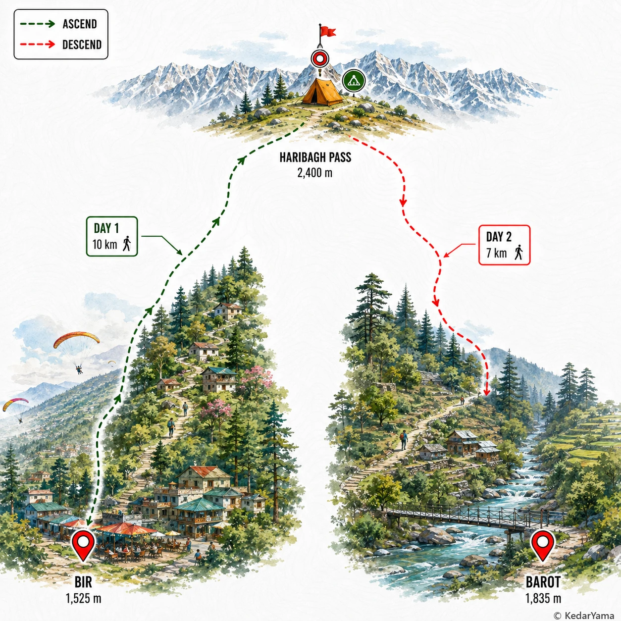
The route begins on village paths above Bir before climbing steadily through oak, pine and rhododendron forests. The middle section follows exposed ridges with wide Dhauladhar views before descending through mixed woodland into the Uhl River valley. There are no technical climbing sections, but the descent can become slippery after rain and trekking poles are strongly recommended.
Spring brings blooming rhododendrons and comfortable daytime temperatures, while autumn offers the clearest mountain views. Monsoon months leave the trail muddy and increase the chance of leeches and landslides on access roads. Winter mornings can be frosty near the pass, with occasional snow lingering on shaded stretches.
Most of the trail passes through Himalayan oak, chir pine and rhododendron forests before dropping into the deodar-covered Barot valley. Himalayan monals, griffon vultures, langurs and numerous mountain birds are commonly spotted. The forests around Barot also form part of habitat connected to the Nargu Wildlife Sanctuary.
The trek remains below 2,500 metres, so altitude sickness is uncommon for healthy trekkers. The main challenge comes from the long climb to the pass followed by a sustained descent into Barot. A reasonable level of cardiovascular fitness and regular hydration are sufficient for most first-time trekkers.
March – June
Pleasant days, cool nights and blooming rhododendrons make this the most comfortable trekking season. Trails stay dry and mountain views are usually excellent.
July – August
The forests become lush but rain can make trails slippery and mountain roads prone to landslides. Travel is possible but requires flexible plans.
September – November
Fresh post-monsoon air brings some of the clearest views of the Dhauladhar range. Comfortable temperatures make this the favourite season for trekking and camping.
December – February
Higher sections may receive snowfall while Barot remains quiet and peaceful. Expect cold nights and occasional weather-related road disruptions.
Required: No
No standard trekking permit is normally required for the Bir to Barot trail, though organised groups may complete local forest or campsite registrations where applicable.
The nearest medical facilities are at Bir and Barot, with larger hospitals available in Baijnath and Mandi. Inform your accommodation or guide before beginning the trek, as network coverage is intermittent.