RM
Rahul Mehta
September 2025
“I expected the lake to be the highlight, but the endless green meadows completely surprised me. Every campsite had mountain views in every direction.”
Pir Panjal Range, Kullu Valley, Himachal Pradesh
“Walk across endless alpine meadows from Manali to a sacred 4,300 m glacial lake beneath the Pir Panjal peaks.”
Altitude
13999 ft
Duration
4 Days
Difficulty
Easy to Moderate
Best time
Jun – Jul Aug – Sep
Updated 10 Aug 2026
Max altitude
13,999 ft
Duration
4 Days
Total distance
22 km
Elevation gain
5,699 ft
Trek type
Out and Back
Starting point
Gulaba
Trail type
Forest, meadows and alpine ridge
Average cost (indicative)
₹4,500–₹8,500 per person
Temp. range (°C)
5°C to 20°C
Snow months
May to early June
Rain risk
High during July and August monsoon
Nearest Town
Manali
Base Camp Drive
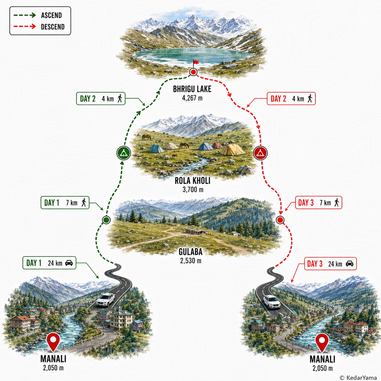
Manali to Gulaba (around 24 km, 1–1.5 hours)
Best Season
Mid May to September
Network
Available till Gulaba; very limited beyond
Trekking Boots
3-Layer Clothes
50L Backpack
Hydration
Trekking Pole
Down Jacket
Thermal Layers
Headlamp
Gloves

Woolen Socks
First Aid Kit
Rain Jacket
Power Bank
Action Cam
Quick-dry Towel
Hydration Bladder
Trek Gaiters
Winter Gloves
Sunglasses
Lip Balm
The trek begins from Gulaba and climbs steeply through mixed oak and cedar forest before opening into vast alpine meadows much earlier than most Himalayan treks. Higher up, the route follows grassy ridges with rocky patches and occasional snowfields in early summer. The final stretch to Bhrigu Lake is exposed to wind and can become slippery after rain. Although the trail is well defined in clear weather, fog can quickly reduce visibility across the open grasslands.
Despite being a beginner-friendly trek, Bhrigu Lake gains altitude rapidly from around 2,530 m at Gulaba to over 4,260 m in just two trekking days. This quick ascent makes acclimatization the biggest challenge. Staying hydrated, maintaining a slow pace and immediately reporting headache, nausea or dizziness are essential to reduce the risk of Acute Mountain Sickness.
From May through June, lingering snow remains around the lake while the meadows slowly turn green. July and August transform the trail into carpets of wildflowers but also bring monsoon showers, muddy slopes and occasional road delays. September usually offers the clearest mountain views with cool days and cold nights. Weather changes rapidly, so every trekker should carry waterproof layers regardless of the forecast.
The lower forests are filled with oak, deodar and maple trees before giving way to expansive alpine grasslands dotted with seasonal wildflowers. On clear days the ridges offer uninterrupted views of Hanuman Tibba, Deo Tibba, the Seven Sisters peaks and parts of the Pir Panjal range. Himalayan monal, marmots, grazing sheep and mountain horses are commonly seen depending on the season.
Mid June – Early July
Early-season trekkers usually cross lingering snow patches before reaching the lake. The meadows are just turning green, the air is crisp and the lake often remains partially frozen.
July – August
This is when Bhrigu Lake is at its greenest. Alpine meadows fill with wildflowers and grazing horses, although afternoon clouds and occasional rain are common.
September
After the monsoon begins to fade, the skies become clearer and long-distance mountain views improve dramatically. The meadows remain green while the weather is generally more stable.
Required: Yes
Forest entry and camping permissions are generally arranged by registered trek operators. Independent trekkers should confirm current forest regulations at Gulaba or with the local forest office before starting. No separate Rohtang Pass permit is normally required when trekking from Gulaba.
The nearest major medical facilities are in Manali. Mobile connectivity is unreliable beyond Gulaba, so organized groups generally carry radios or satellite communication for emergencies. Evacuation is normally done on foot back to Gulaba before vehicle transfer.