Bali Pass Trek

Garhwal Himalayas, Uttarakhand

A demanding high-altitude pass crossing from Har Ki Dun to Yamunotri with Ruinsara Tal, glaciers, and 16,207 ft Himalayan views.

Altitude

16240 ft

Duration

8 Days

Difficulty

Expert

Best time

May – Jun Sep – Oct

Standout Experiences

  • Cross one of Uttarakhand's toughest trekking passes and watch the landscape change from forests to glaciers in a single journey.
  • Camp beside the emerald waters of Ruinsara Tal, one of the quietest alpine lakes in the Garhwal Himalayas.
  • Stand at 16,207 ft with panoramic views of Swargarohini, Bandarpoonch, and Kala Nag stretching across the horizon.
  • Finish your trek at the holy town of Yamunotri instead of returning the same way, making the route feel like a true Himalayan crossing.

Overview

Updated 10 Aug 2026

  • The Bali Pass Trek is one of the most rewarding high-altitude pass crossings in the Garhwal Himalayas. Starting from the Sankri region, the trail follows the famous Har Ki Dun valley before climbing to the peaceful shores of Ruinsara Tal. Every day feels different. You'll walk through ancient pine forests, cross wooden bridges over glacier-fed rivers, camp in wide alpine meadows, and slowly leave the tree line behind as snowfields and rocky ridges take over. By the time you stand on Bali Pass at 16,207 ft, you've crossed one of Uttarakhand's most respected trekking routes.
  • What makes the Bali Pass Trek unforgettable is how dramatically the landscape changes. One side of the pass looks back toward the green Har Ki Dun valley and the towering Swargarohini massif, while the other drops steeply toward Yamunotri through rugged glaciers and loose moraine. On a clear morning, peaks like Bandarpoonch, Kala Nag (Black Peak), and Swargarohini dominate the skyline. The final descent ends at the sacred Yamunotri temple, giving this adventure a rare combination of wilderness and pilgrimage that very few Himalayan treks can match.

Trek essentials

Max altitude

16,240 ft

Duration

8 Days

Total distance

64 km

Elevation gain

10,007 ft

Trek type

Point-to-point

Starting point

Sankri

Trail type

Forest, meadow, glacier and high-pass crossover

Average cost (indicative)

₹22,000–₹28,000 per person

Temp. range (°C)

-8°C to 22°C

Snow months

May-June, October

Rain risk

High during July-August monsoon

Best Season

Mid-May to June and September to mid-October

End Point

Janki Chatti (Yamunotri)

Nearest Railhead

Dehradun

Nearest Airport

Jolly Grant Airport, Dehradun

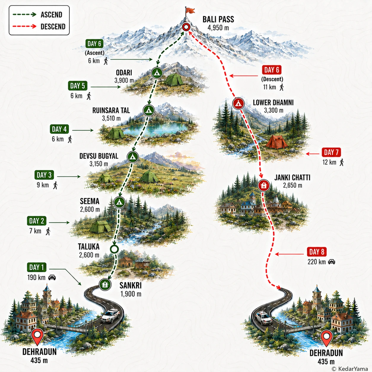
Trek Route

Graphical route map — high resolution terrain visualization

Detailed Itinerary

holiday_villageStayHomestay
signal_cellular_altDataPartial
boltPowerAvailable
  • Meet around 6:30-7:00 AM in Dehradun and begin the 200 km drive that takes roughly 8-10 hours to reach Sankri.
  • The road follows the Yamuna and Tons valleys through Mussoorie, Purola, Mori and Netwar with plenty of mountain viewpoints and roadside dhabas.
  • Reach Sankri by evening, complete equipment checks, enjoy the first views of Swargarohini and rest early for the trek ahead.

Packing List

Must Have

Trekking Boots

layers

3-Layer Clothes

backpack

50L Backpack

water_drop

Hydration

timeline

Trekking Pole

ac_unit

Down Jacket

thermostat

Thermal Layers

front_hand

Winter Gloves

Woolen Socks

Woolen Socks

lightbulb

Headlamp

medical_services

First Aid Kit

Good to Have

battery_charging_full

Power Bank

photo_camera

Action Cam

checkroom

Quick-dry Towel

directions_walk

Trek Gaiters

water_full

Hydration Bladder

back_hand

Gloves

Technical Overview

terrain

A true Himalayan crossover

The Bali Pass Trek links the Har Ki Dun valley with Yamunotri instead of returning on the same trail. Expect dense pine, oak and deodar forests, flower-filled alpine meadows, boulder fields, glacial streams, moraine and long snow slopes before reaching the high pass. The summit day involves sustained climbing on steep snow or loose rock depending on the season, followed by an equally demanding descent.

info

Acclimatization is critical

The trail climbs from around 1,900 metres at Sankri to 4,950 metres at Bali Pass in less than a week. Camps are spaced to allow gradual altitude gain, but trekkers should arrive fit and well hydrated. AMS symptoms should never be ignored because evacuation becomes difficult once above Ruinsara Tal.

ac_unit

Weather changes quickly

Days are usually pleasant in late spring and autumn, while nights remain well below freezing at higher camps. Snowfields often persist until June, and fresh snowfall is possible even in October. Strong winds are common around Odari and the pass, making proper layering essential.

info

From forests to alpine wilderness

The lower valley is filled with deodar, walnut, oak and rhododendron forests before opening into the meadows of Devsu Bugyal and the pristine surroundings of Ruinsara Tal. Himalayan monal, langur, bharal and occasional musk deer may be spotted. Above the tree line the landscape becomes stark, rocky and glacial with dramatic views of Swargarohini, Kala Nag and Bandarpoonch.

When to Visit

calendar_today

Snow crossings and blooming valleys

May – June

Summer is the classic season for Bali Pass. Lower forests are green with blooming rhododendrons, while higher camps and the pass still hold enough snow to make the crossing adventurous. Days are pleasant, but nights remain cold at higher camps.

calendar_today

Crystal-clear mountain views

September – October

After the monsoon, the trail becomes lush and the skies are usually at their clearest. Autumn colors begin to appear across the meadows, mountain visibility is outstanding, and weather conditions are generally more stable for crossing the pass.

Other Information

Logistics & inclusions

  • check_circleDrive from Dehradun to Sankri takes 8-10 hours via Mussoorie, Purola, Mori and Netwar.
  • check_circleMost operators provide transport from Dehradun and return from Janki Chatti.
  • check_circleThe trek starts from Sankri after a short drive to Taluka depending on road conditions.
  • check_circleForest permits are generally arranged by registered trek operators.
  • check_circleMobile connectivity is reliable only until Sankri; expect no network through most of the trek.
  • check_circleExtra luggage can usually be left at Sankri base accommodation.

Permits

Required: Yes

Entry permit for Govind Pashu Vihar National Park and forest camping permissions are required. Registered trek operators normally include these charges in the trek fee.

Safety

Risks

  • Acute Mountain Sickness above 3500 m
  • Steep snow climb and descent on Bali Pass
  • Rapid weather changes with snowfall and strong winds
  • River crossings early in the season
  • Long summit day causing fatigue

Precautions

  • Attempt only with prior high-altitude trekking experience.
  • Maintain slow ascent, hydrate regularly and report AMS symptoms immediately.
  • Carry proper waterproof boots, gaiters and layered clothing.
  • Start summit day before dawn to cross snow before it softens.
  • Follow trek leader instructions during snow and exposed traverses.

Emergency

The quickest evacuation is generally toward Janki Chatti after crossing the pass or back toward Sankri before summit day. Satellite communication or radio carried by organized groups is recommended because mobile coverage is absent.

Reviews

Frequently Asked Questions

Is the Bali Pass Trek suitable for beginners?expand_more
What is the best time to do the Bali Pass Trek?expand_more
How do I reach the Bali Pass Trek from Delhi?expand_more
Will I find snow on the Bali Pass Trek?expand_more
Do I need permits for the Bali Pass Trek?expand_more
How difficult is the summit day on the Bali Pass Trek?expand_more
Bali Pass Trek or Rupin Pass Trek: which should I choose?expand_more